


Terra Map - Trail Explorer
Terra Map - Trail Explorer का विवरण
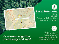
आउटडोर नेविगेशन के लिए सर्वोत्तम तकनीक के साथ सुरक्षित रूप से हर साहसिक कार्य का आनंद लें।
अनुभवी हाइकर्स और बाइकर्स की मदद से विकसित टेरा मैप आपकी सभी जरूरतों को पूरा कर सकता है।
►► विशेषताएं:
• स्मार्टफोन और टैबलेट दोनों पर उपयोग के लिए अनुकूलित
• दुनिया भर में अविश्वसनीय रूप से सटीक और पढ़ने में आसान मानचित्र
• मानचित्र ऑफ़लाइन उपयोग के लिए डाउनलोड करें
• मानचित्र पर किसी भी बिंदु के लिए मौसम का पूर्वानुमान (टेरा मानचित्र प्रो उपयोगकर्ता केवल)
• लाइव शेयरिंग-टेरा मानचित्र समुदाय
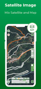
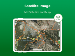
• सैटेलाइट चित्रण
• मानचित्र की बेहतर पठनीयता के लिए चिह्न और पाठ अनुकूलन
• विभिन्न स्वरूपों में मार्करों और मार्गों के लिए आसान साझाकरण
• भू-संदर्भित तस्वीरें
• निरंतर ट्रैक रिकॉर्डिंग के 14 घंटे तक अनुकूलित बैटरी उपयोग
• ऐप खरीद के माध्यम से प्रो मोड को सक्रिय करके असीमित मात्रा में डेटा स्टोर करने की क्षमता
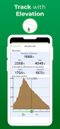
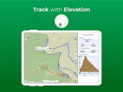
• ऊंचाई और गति प्रोफ़ाइल
► मैप्स
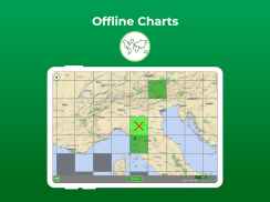
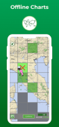
टेरा मानचित्र आपको पूरी दुनिया के मानचित्रों को समोच्च रेखाओं, पगडंडियों, आश्रयों और आपकी अगली बढ़ोतरी के लिए आवश्यक सभी चीजों के साथ मुफ्त में डाउनलोड करने की अनुमति देता है। एक बार डाउनलोड हो जाने के बाद, मानचित्रों का उपयोग बिना इंटरनेट कनेक्शन के भी किया जा सकता है।
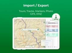
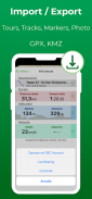
► लोड हो रहा है और मार्करों और मार्गों को साझा करना
आप टेरा मैप या अन्य तृतीय-पक्ष एप्लिकेशन/नेविगेटर के साथ बनाए गए ट्रैक और मार्कर को आसानी से निर्यात और आयात कर सकते हैं। इंटरनेट पर उपलब्ध या किसी मित्र (GPX या KMZ प्रारूप) द्वारा साझा किए गए किसी भी मार्ग को प्रबंधित करें।
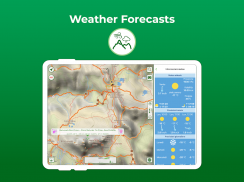
► मौसम पूर्वानुमान
दुनिया में मानचित्र पर किसी भी बिंदु का चयन करें और अगले 7 दिनों के लिए मौसम का पूर्वानुमान प्राप्त करें (केवल टेरा मैप प्रो उपयोगकर्ताओं के लिए)।
► ऊंचाई और गति
प्रत्येक रिकॉर्ड किए गए ट्रैक के लिए एलिवेशन प्रोफाइल और स्पीड ग्राफ उपलब्ध होंगे।
► अनुकूलित बैटरी उपयोग
पूरे दिन काम करने के लिए डिज़ाइन किए गए, टेरा मैप में एक बैटरी मॉनिटरिंग सिस्टम भी शामिल है, जो सक्रिय रिकॉर्डिंग के मामले में, डिवाइस को बिजली से बाहर जाने से रोकने के लिए स्वचालित रूप से ट्रैक को रोक देगा।
नोट: प्रभावी बैटरी अवधि बैटरी की स्थिति, तापमान और डिवाइस के उपयोग पर निर्भर करती है।
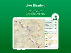
► लाइव शेयरिंग
Terra Map समुदाय के साथ अपना डेटा साझा करने और अपने आसपास के सभी सक्रिय उपयोगकर्ताओं को देखने के लिए लाइव शेयरिंग सक्षम करें। आप उनके साथ चैट कर सकते हैं और ऐप को छोड़े बिना अपने मार्कर/ट्रैक भेज (और प्राप्त) कर सकते हैं।
► खरीद का प्रकार
सदस्यता: भुगतान आपके खाते (Google खाता) के माध्यम से किया जाएगा। समाप्ति तिथि से कम से कम 24 घंटे पहले रद्द किए जाने तक वार्षिक सदस्यता स्वचालित रूप से नवीनीकृत हो जाएगी। उपयोगकर्ता अपनी सदस्यता का प्रबंधन कर सकता है और खरीद के बाद खाता सेटिंग अनुभाग में स्वत: नवीनीकरण बंद कर सकता है।
असीमित: आप नक्शों को हमेशा के लिए डाउनलोड और अपडेट कर सकते हैं।
टेरा मैप कुछ सीमाओं के साथ एक मुफ्त संस्करण में उपलब्ध है।
नियम और शर्तें: https://www.terramap.app/terms-and-conditions
गोपनीयता नीति: https://www.terramap.app/privacy-policy
Terra Map - Trail Explorer - Version 31.7
(22-10-2024)Terra Map - Trail Explorer - एपीके जानकारी
एपीके संस्करण: 31.7पैकेज: com.gec.TerraApp.TerraLatest Version of Terra Map - Trail Explorer
अन्य संस्करण


Apps in the same category


